| Aug 09, 2012 |
NASA's Curiosity beams back a color 360 of Gale Crater
|
|
(Nanowerk News) The first images from Curiosity's color Mast Camera, or Mastcam, have been received by scientists at NASA's Jet Propulsion Laboratory in Pasadena, Calif. The 130 low-resolution thumbnails, which were received Thursday morning, provide scientists and engineers of NASA's newest Mars rover their first color, horizon-to-horizon glimpse of Gale Crater.
|
|
"After a year in cold storage, where it endured the rigors of launch, the deep space cruise to Mars and everything that went on during landing, it is great to see our camera is working as planned," said Mike Malin, principal investigator of the Mastcam instrument from Malin Space Science Systems in San Diego. "As engaging as this color panorama is, it is important to note this is only one-eighth the potential resolution of images from this camera."
|
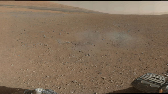 |
| This is a portion of the first color 360-degree panorama from NASA's Curiosity rover, made up of thumbnails, which are small copies of higher-resolution images. The mission's destination, a mountain at the center of Gale Crater called Mount Sharp, can be seen in the distance, to the left, beginning to rise up. The mountain's summit will be imaged later. The full thumbnail panorama from the Mast Camera can be seen at PIA16029. Blast marks from the rover's descent stage are in the foreground.
|
|
The Curiosity team also continued to downlink high-resolution black-and-white images from its Navigation Camera, or Navcam. These individual images have been stitched together to provide a high-resolution Navcam panorama, including a glimpse of the rover's deck. Evident on some portions of the deck are some small Martian pebbles.
|
|
"The latest Navcam images show us that the rocket engines on our descent stage kicked up some material from the surface of Mars, several pieces which ended up on our rover's deck," said Mike Watkins, mission manager for Curiosity from JPL. "These small pebbles we currently see are up to about 1 centimeter [0.4 inch] in size and should pose no problems for mission operations. It will be interesting to see how long our hitchhikers stick around."
|
|
Mission engineers devoted part of their third Martian day, or "Sol 3," to checking the status of four of Curiosity's science instruments after their long trip. The rover's Alpha Particle X-ray Spectrometer, Chemistry and Mineralogy analyzer, Sample Analysis at Mars, and Dynamic of Albedo Neutrons instruments were each energized and went through a preliminary checkout. The team also performed a check on the rover's second flight computer.
|
|
Even before landing, the mission's science team began the process of creating a geological map of about 150 square miles (about 390 square kilometers) within Gale Crater that includes the landing area.
|
|
"It is important to understand the geological context around Curiosity," said Dawn Sumner of the University of California, Davis, a member of the Curiosity science team. "We want to choose a route to Mount Sharp that makes good progress toward the destination while allowing important science observations along the way."
|
|
The mapping project divided the area into 151 quadrangles of about one square mile (about 2.6 square kilometers) each. Curiosity landed in the quadrangle called Yellowknife. Yellowknife is the city in northern Canada that was the starting point for many of the great geological expeditions to map the oldest rocks in North America.
|
|
Curiosity carries 10 science instruments with a total mass 15 times as large as the science payloads on NASA's Mars rovers Spirit and Opportunity. Some of the tools, such as a laser-firing instrument for checking rocks' elemental composition from a distance, are the first of their kind on Mars. Curiosity will use a drill and scoop, which are located at the end of its robotic arm, to gather soil and powdered samples of rock interiors, then sieve and parcel out these samples into the rover's analytical laboratory instruments.
|
|
To handle this science toolkit, Curiosity is twice as long and five times as heavy as Spirit or Opportunity. The Gale Crater landing site places the rover within driving distance of layers of the crater's interior mountain. Observations from orbit have identified clay and sulfate minerals in the lower layers, indicating a wet history.
|