| May 21, 2014 |
SWARM is drawing the Earth's magnetic field in 3D
|
|
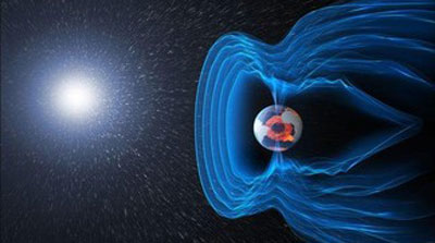
(Nanowerk News) Thanks to a constellation of three satellites, ESA’s SWARM mission will track and measure the planet’s magnetic forces from its core to its upper atmosphere. Five months after the launch, the satellites are beginning to gather data.
|
 |
|
The SWARM mission is now fully deployed. Five months after they were launched, the three satellites are now positioned onto their respective orbits and have begun sending their first data “with a precision that took earlier missions 10 years to achieve”, European Space Agency (ESA) specialists comment on the mission’s website. For four years, the satellites will track and measure the strength, direction and changes in the Earth's magnetic field. The project will give scientists unprecedented insight into the subtle workings of this force field that act like a shield protecting our biosphere from the Sun’s charged particles, heavy ions and cosmic radiation.
|
|
This rich collection of data will be used in many different ways. First of all, the scientists will model the geomagnetic field and its interaction with other physical aspects of the Earth. To be monitored are the magnetic properties of the planet’s core all the way to its upper atmosphere, thus offering a unique view of the composition and processes of the planet interior, as well as the atmospheric and ocean processes that affect climate and weather. Furthermore, the mission will investigate how the Earth’s slight oblateness affects the force and intensity of gravity from one location to another.
|
|
“There is one more goal,” says scientist Florian Gallien at the Swiss space Center. “The magnetic field has weakened by 10-15% over the last 200 years, meaning that an inversion of the poles may be possible. The South could become the North and conversely and has already happened in the past. SWARM will watch how it evolves over time.
|
|
The mission involves three satellites, orbiting at different heights. Two of them are flying at 460 km above the Earth and at 150 kilometers from each other. The third is at an altitude of 510 km. “The higher you go, the weaker the magnetic field,” adds Florian Gallien. “This rare configuration of satellites covers a larger area and offers a more complete 3D picture of our planet’s magnetic profile.”
|
|
Each satellite is equipped with sophisticated and highly precise instruments, such as three powerful fluxgate vector magnetometers, placed on long branches in order to preserve them from the magnetic fluctuations produced by the spacecraft itself. There are also accelerometers for the measurement of air-drag, winds, the Earth’s albedo and solar radiation pressure, as well as instruments for the observation of ion density, drift velocity and electric fields.
|