| May 14, 2022 |
Drones and machine learning help reveal the scale of plastic pollution |
| (Nanowerk News) Plastic pollution is a major global issue but grasping the scale of the problem can be challenging. In a recent study (Scientific Reports, "Mapping riparian zone macro litter abundance using combination of optical and thermal sensor"), researchers from the University of Tsukuba developed a novel method for mapping plastic litter around rivers. |
| As the human population grows, so too does the amount of waste produced. Plastic can now be found in every environment on Earth. Riparian environments can be hotspots for pollution as rivers collect and transport waste along their course. In rivers, plastic waste can reduce water quality, increase flood risk, and harm plant and animal species that use the river and surrounding habitats. A first step in addressing the litter problem is understanding where plastic is accumulating. |
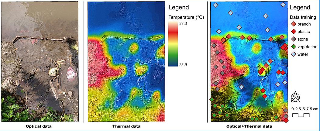 |
| Clipped orthomosaic of optical and thermal sensor data, and a combination of both data and the distribution of the training data used around the riparian zone. This figure was created using QGIS Desktop version 3.18.1, available at https://download.qgis.org/downloads/. (Image: University of Tsukuba) |
| "Many techniques have been tested to map litter in different environments but these are often complex or expensive," says lead author of the study, Professor Fatwa Ramdani. "We set out to find a simpler, cost-effective means of mapping pollution in riparian systems that can be broadly applied." |
| To do this, the researchers used a combination of very high resolution optical and thermal images, collected using low-flying drones. The drones were used to detect plastic pollution along the Brantas River, Malang City, in Indonesia. A machine learning approach was then used to process the images. Three different machine learning classifiers were tested to see which could most accurately recognize different types of objects, including plastics. |
| "Using these methods, we found that a combination of optical and thermal images produced the most accurate estimates of the amounts of plastic litter," explains Professor Ramdani. "On their own, neither image type produced particularly accurate results." |
| The researchers also found that one classification method – XGBoost – performed better than the others tested. Some challenges still remain with this method. For example, whether plastic was floating on the surface or submerged in the water affected the results to some extent. |
| Nevertheless, this novel method is a helpful step toward identifying pollution hotspots. Understanding where plastics are accumulating in the environment can help target clean-up efforts and may provide insights into the sources of pollution. |
| Source: University of Tsukuba |