| Aug 27, 2015 |
Ceres close up
|
|
(Nanowerk News) NASA’S Dawn space probe has reached the last intermediate leg on the spiral orbit which will bring it to within a few hundred kilometres of the dwarf planet Ceres by the end of the year. Ceres is the largest celestial body in the asteroid belt between Mars and Jupiter. Since 17 August, the Dawn spacecraft has been a mere 1470 kilometres away from its surface. The first images from this new orbit are now available. With a resolution of 140 metres per pixel, they allow the most detailed look to date at a distant world: at countless small craters, surprisingly sharp-edged, precipitous mountain ridges – and at a pyramid-shaped, six-kilometre-high mountain, which turns out to be a kind of high plateau.
|
 |
|
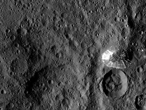
Processed image of the pyramid-shaped mountain with high plateau in Ceres’ southern hemisphere between the Kirnis, Rongo und Yalode craters. The table mountain is around six kilometres high and its longitudinal axis measures around 20 kilometres. Bright, ray-like structures permeate its mountain slopes. These could be granular or liquid flows with water involved in the past. The image was taken on 19 August 2015 from a distance of 1470 kilometres. (Image: NASA/JPL-Caltech/UCLA/MPS/DLR/IDA) (click on image to enlarge)
|
|
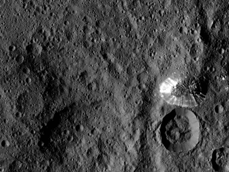
“Many of the surface structures which we have discovered over the past weeks and months are unique and mysterious,” says Andreas Nathues from the Max Planck Institute for Solar System Research in Göttingen, who is the leader of the Dawn camera team. “We can now finally see them with a resolution which is three times better.” In addition to the bright spots scattered over the surface of the dwarf planet, the researchers are especially fascinated by an unusual mountain in Ceres’ southern hemisphere. With an impressive height of around six kilometres, it rises above the plane between the craters known as Kirnis, Rongo and Yalode.
|
|
The structure of the mountain top can be seen much more clearly than before. “It is actually more a type of high plateau. The surface looks strikingly similar to the surroundings at the foot of the mountain,” is how Nathues describes it. The sides of the mountain descend steeply and smoothly, permeated by bright, ray-like structures. It is unclear how this mountain was formed and whether there is a connection to the large crater roughly equal in size which borders it directly to the south. “The bright rays are possibly flow structures,” says Martin Hoffmann, a member of the camera team at the Max Planck Institute for Solar System Research. Investigations over the coming months should show whether they are connected to possible cryovolcanism.”
|
|
Impacts could have melted underground ice
|
|
Researchers have suspected for years that there is a layer of frozen water below the surface of Ceres. The comparatively low density of the body is an indication of such a structure. The bright spots and ray-like structures could support this theory. It is conceivable that impacts have exposed the underground ice in some places. The heat of the impact could also have melted the underground ice; water could have pushed its way to the surface, to flow and refreeze. Researchers call this phenomenon cryo- or ice volcanism.
|
|
A further indication for Ceres’ unusual layered structure are craters whose centre has a sunken region like a sort of hole. “The layers under the surface appear to give way in places,” says Nathues.
|
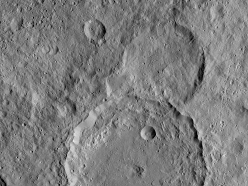 |
| In the centre of the Gaue crater, whose diameter is around 84 kilometres, the ground has partially sunk in the bottom half of the image. This indicates that Ceres is made up of several layers. The image was taken on 18 August 2015. (Image: NASA/JPL-Caltech/UCLA/MPS/DLR/IDA) (click on image to enlarge)
|
|
The first images from the new orbit do not yet show all of Ceres’ surface. It is not yet possible to see the most striking bright spots, for example. At the moment, Dawn needs 19 hours to orbit Ceres once. Since each image section covers less than one percent of the surface, several orbits are required to map the celestial body completely. Dawn will remain in its new orbit until the end of October. The space probe will then reach its last, lowest orbit in December. It will then be a mere 375 kilometres above the surface.
|
|
The Dawn Mission is managed by the Jet Propulsion Laboratory (JPL) of the American space agency NASA. JPL is a department of the California Institute of Technology in Pasadena. The University of California in Los Angeles is responsible for the scientific part of the mission. The camera system aboard the spacecraft was developed and built under the direction of the Max Planck Institute for Solar System Research in Göttingen in collaboration with the Institute of Planetary Research of the German Space Center (DLR) in Berlin, and the Institute of Computer and Network Engineering in Braunschweig. The camera project is supported financially by the Max Planck Society, the DLR and NASA/JPL.
|